NAVIGATION. This page is a subpage of In the News – Wildfire/Extreme Weather on the website Nova Scotia Forest Matters (www.nsforestmatters.ca)
 Post by Bev Wigney on
Annapolis Environment & Ecology (Public FB Page)
LAKE GEORGE FIRE — SEPTEMBER 30::
I’m not sure if this fire will be named as the Lake George Fire, but I think so. I’ll try to post the most recent info about it.
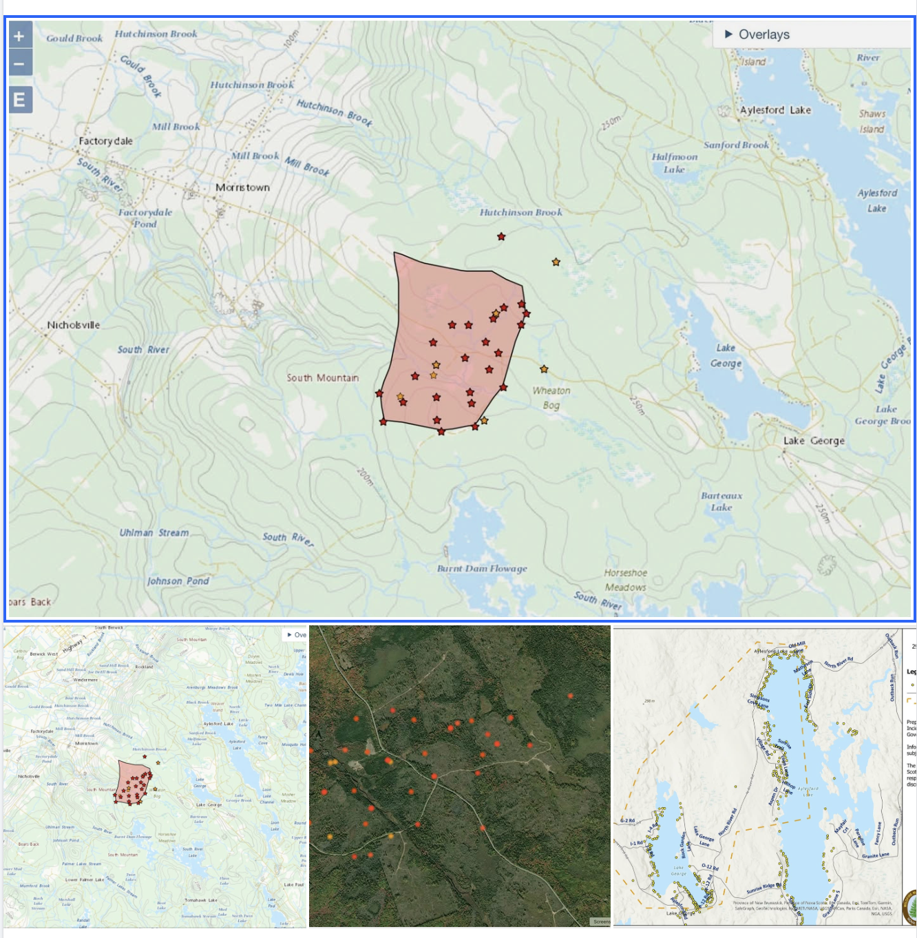
I know that most of our members are probably in Annapolis County, but we have many in Kings County as well, so I’ll try to provide info I’ve found about the fire so far today. The fire maps I’m posting came from the NRCAN Canada Wildlands Fire Map website (2 of those – one zoomed out to show the location of the fire relative to local towns, the other shows a more zoomed in version). I am also including a map from FireMap.live which shows a satellite view of the fire zone, with hotspots marked in. Some may find this interesting to see what the terrain looks like and where the fire has spread. As of this morning, the NRCAN map site says that the fire perimeter estimate is 326 hectares. That is considerable growth since yesterday morning. I’m also including the most recent map that I could find of the evacuation zone for the fire. Obviously this is probably going to change, so be sure to consult the provincial emergency alert FB page for updated maps.
I don’t have a lot of information on what’s happening at the fire other than what I have found by looking at a few Facebook pages. I think the following information is fairly dependable – these are from X(Twitter) posted by NS Natural Resources at 22:59 hours last night (Sept 29). This is what the text on the two releases said:
1.) Windy conditions are causing the Lake George wildfire to grow. An accurate estimate is difficult given the amount of smoke — rough estimate is 300 hectares. It is moving from the northern end of Lake George eastward toward the northern end of Aylesford Lake.
2.) Further evacuations ordered by KingsCountyNS. 17 DNR firefighters worked with local fire dept, supported by 4 NWT 802 and 2 Quebec 415 aircraft (water bombers). All returning at first light with heavy equipment to build fire breaks. Fire will be monitored overnight. Next update tomorrow morning.
NOTE:: These are from last night — we should be seeing updates sometime this morning.
THAT’S ALL FOR NOW. I WILL TRY TO UPDATE INFO AS I SEE IT.
—–
From the Comments:
LMDR: It awful to have this happening, and that area has a lot of ” forest management” clearcuts done, over fairly large areas on both sides of the road. I used to do some fishing and foraging around where the fire started until the “forest management” destroyed the beauty of the area. I certainly hope they can get it under control quickly and no one loses their properties.
Reply by BW:Yes, there does appear to be a lot of cutting where the fire is burning. I noticed the same thing with the Long Lake Fire. If you compare the Copernicus satellite views of the fire (burned area) with other satellite views from various dates *before* the fire, it seemed to be burning in areas of previous harvests, plantations, etc.. The areas of older hardwoods (based on what I can tell from studying the Provincial Landscape Viewer using the “forest stand” info of leading species, etc..) did not seem to get as burnt and appear as the green areas within the blackened areas of the Copernicus maps. Hopefully someone who is in charge of forestry will be taking a look at that and giving some consideration as to why the maps and forest look the way they do.
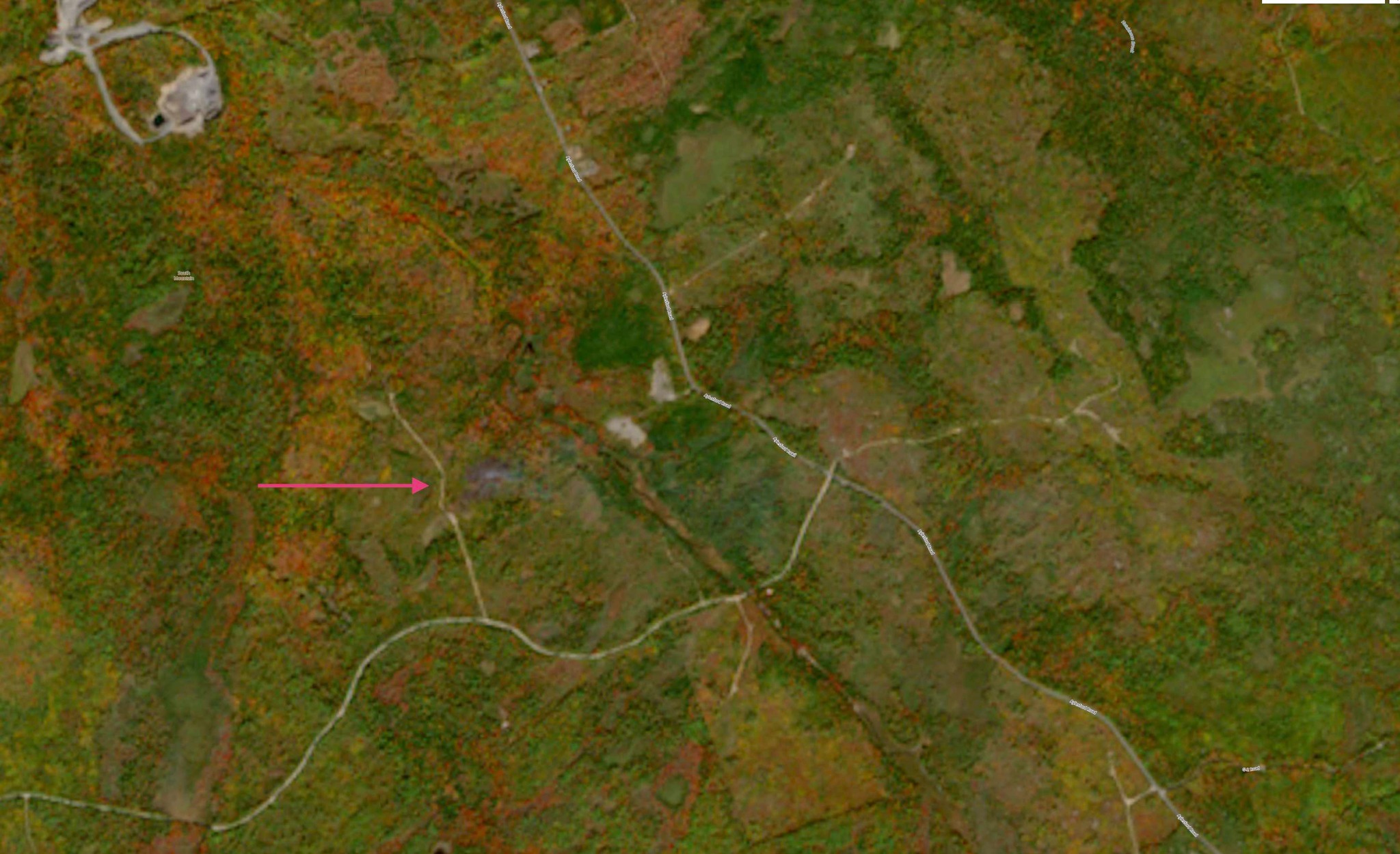
A few of you have been asking where the fire started. I’ve been watching the Copernicus satellite website to see if the beginning of the fire would show up. I just found it on yesterday’s satellite pass (September 29). I’m not sure exactly at what time this image was taken, but it does show the beginning of the fire — that smoky bluish area up the little lane that runs off of the side of what was probably a logging road with a landing or turnaround. You’ll have to zoom in on the image to see the spot where there is some wispy smoke . I just used Google Earth to look at that area more closely and see that there is some kind of road that continues on from that spot — just something — probably used by ORVs — it winds around for a while and then comes out on Aylesford Road further north of the fire. Anyhow, here’s the image for those of you who are curious. Unfortunately, the resolution is not high as I don’t have a “paying” account with Copernicus.