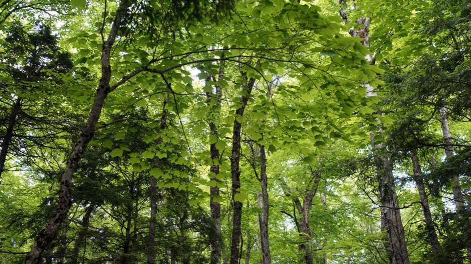

An old Yellow Birch in the Goldsmith Lake area
By Nina Newington
Page posted on NSFM Apr 10, 2025
Navigation:
NSFM/20% Protection by 2030/Stories Maps Tell/This Page
At right: This old Yellow Birch in the Goldsmith Lake area was revealed by our coring to be well over 300 years of age. It is located in an area that the Bowater map shows as having been cut and treated in 1971-72. Hence it was assumed by DNR not to host any old growth forest. Our citizen science observations led DNR to investigate and finally to recognize the existence of old growth stands within areas managed and harvested by Bowater between 1970 and 2012.
CONTENTS
1. BACKGROUND
At issue in this ongoing series by Nina Newington is whether 3900 hectares of Crown land around Goldsmith Lake in Annapolis County should be protected, as citizen scientists propose, or whether it should remain available for forestry and other industrial activities.
In Stories Maps Tell I: Just Not True, posted Feb 2, 2025, I described the Bowater map for the area and how DNR uses this map to justify logging in this area, maintaining that it is largely “managed forest” that was cut or treated between 1970 and 2012. However close examination of the map shows that there is a LOT of forest that was not touched during Bowater’s tenure.
In Stories Maps Tell II: Where the Bowater map gets it right, I show that, except for some old forest clearcut by WestFor after Bowater went bankrupt, areas west of Goldsmith Lake shown as untouched on the Bowater map are of high conservation value. Some stands were assessed as old-growth forest by DNR in 2023. In others, a survey of calicioid (stubble) lichens by Citizen Scientists demonstrated a level of ecological continuity typical of old-growth forest. Neither DNR’s old-growth assessments nor the scientific article published about the Citizen Scientists stubble lichen survey seemed to change DNR’s “managed forest” narrative about the area.
Now, in Stories Maps Tell III: Where the Bowater Map got it wrong plus a new map to enjoy, my starting point is the discovery of old-growth forest on a peninsula in Goldsmith Lake that the Bowater map shows as having been cut and treated in 1971-72. This leads into a broader examination of the stories DNR tells and the ones it chooses not to tell. In the face of the curious secrecy surrounding the existence of multiple stands of old-growth forests around Goldsmith Lake, the vital importance of Freedom of Information requests is revealed.
2. INTRODUCTION
The Bowater map was created by the Bowater-Mersey pulp mill to document the forestry work they conducted in the 10,000 acres/4000 ha they owned around Goldsmith Lake between 1970 and 2012. In November of 2022, DNR attached this map to briefing notes they created for Minister Tory Rushton after CBC covered Citizen Scientists’ discoveries of species at risk lichens in the area.* A year later, DNR attached it to another set of briefing notes for the same Minister.
*See Logging paused in Annapolis County forest after identification of species at risk by Paul Palmeter for CBC News Nov 29, 2022
DNR used the Bowater map to tell a story, the story that the area around Goldsmith Lake has been so extensively cut over (managed) that it is not worth protecting. Upon cross-examination, though, the map has proved to be an unreliable witness for DNR.
Far from indicating that there are few areas intact enough to be worth saving, the map has revealed numerous areas which turn out to exhibit the kind of ecological continuity typical of forests of the highest conservation value, namely old-growth forests. Some of these areas have been assessed by DNR as meeting their criteria for old-growth forest.
Most of these old and old-growth forest stands are found in the places the Bowater map shows were untouched – but not all.
3. THE PENINSULA

Map 1: Bowater’s visual representation of how they managed the Goldsmith Lake area forests between 1970 and 2012. The map was provided in NS Gov’s Freedom of Information response. DNR added harvest plan areas approved in 2022.
Click on images for larger versions.
The peninsula that divides the east and west arms of Goldsmith Lake appears on Bowater’s map to be entirely managed forest, having been either harvested or pre-commercially thinned (PCT) in 1971-1972. Pre-commercial thinning is a ‘treatment’ to thin out the crowded young trees that generally grow back after a clearcut. It can also be used to thin out plantations. It is usually done within 20 years of the original clearcut. So the oldest forest on the peninsula according to this map would be around 75 years old.
The Development Stage layer of DNR’s Provincial Landscape Viewer map paints the same dispiriting picture of the peninsula as having no forest over 80 years old:

Map 2: Screen Capture from NS Provincial Landscape Viewer showing Forest Development Stage Layer for Goldsmith Lake area. Accessed Apr 2, 2025
Establishment means 0-25 years old; Young 26-40; Early Mature 41-80; Late Mature 81-120 years old. Multi-Aged/Old is more complicated (and often disappointing on the ground). It means ‘typically old forests’ over 120 years old with trees of at least three different height classes (see Provincial Landscape Viewer Help Page).
The peninsula, then, appears to be entirely Young (26-40 year old) and Early Mature (41-80) forest. The Development Classes in the Provincial Landscape Viewer are based primarily on tree heights estimated from aerial photographs. The aerial survey on which this map is based was made in 2012.
In the winter of 2022-23, early on in our efforts to protect the Goldsmith Lake Wilderness Area, Beth McClelland, a graduate student in the Geographic Information Systems program at the Center of Geographic Sciences (COGS), worked with us to develop a map that might help us identify the most promising areas to look for species-at-risk lichens. Using provincial LIDAR data, she colour coded tall stands of long-lived hardwood species such as Yellow Birch and Sugar Maple, with the tallest being magenta. Beth’s map showed a magenta band running parallel to the shore in the northeast quadrant of the peninsula. It seemed odd that there should be such tall trees where the forest was all under 80 years old. I filed it away as something to check out in warmer weather, the easiest access being by water.
That July my wife and I went kayaking on Goldsmith Lake for fun. On our way back I paddled over to the eastern shore of the peninsula just to see what I could from the water. As soon as my eyes adjusted to the shade, I began to pick out much larger trees among the scrim of young spruce and balsam fir growing along the shore.
A couple of weeks later, Lisa Proulx and I came back for a proper look. I headed up the slope just in from the lake edge. Lisa followed the toe of the slope northward. When we reconvened, we were both babbling with excitement, she at hefty hemlocks festooned with coral lichen, me at mighty yellow birch and maples spread out along the slope. We soon returned with a larger crew to measure trees, survey for lichens and delight in what was clearly old-growth forest.

 On another trip (it was hard to stay away), Donna Crossland and I took core samples from some trees. The one from a mid-size hemlock 53 cm in diameter at breast height came in at 276 years old. The samples we took from two yellow birches were trickier as both trees were hollow in the middle but, extrapolating from the number of rings we counted in the intact half of the radius, these trees were 350 and 376 years old.

 Clearly both the Bowater map and the Provincial Landscape Viewer were (delightfully) wrong about the age of the forest on the peninsula.
4. CONFLICTING MAPS
DNR maps do exist which show tall, most likely old forest on the peninsula in exactly the place where we found it. The LIDAR mapping which has been conducted for the whole province, for example, yields this map:

Map 3: LIDAR Map. Yellow indicates tree height of 15 – 20 m; orange is 20 – 25 m
Interestingly, even without the more recent LIDAR data, if you dig deeper in the Provincial
Landscape Viewer, turning on the Forest Stand Details layer and zooming in, you start to see a different picture, one that is also more in keeping with what we found.

Map 4. Screen Capture of Stand Details from NS Provincial Landscape Viewer
The pale green may indicate Early Mature as the Development Class but the heights given for the 4.2 hectare stand I outlined in red – 15m – and the 1.8 ha stand outlined in orange – 17 m – suggest older forest. Poplars might reach that height in under 80 years but the main species in the 4.2 ha hardwood stand, according to the map, are slower-growing Red Maple 40%, Sugar Maple 30%, Yellow Birch 20%, Beech 10%. The 1.8 ha stand is shown as Eastern Hemlock 50%, Red Spruce 20%, Red Maple 20%, White Pine 10%. With the possible exception of red maple, these are all long-lived, shade-tolerant species – classic components of old-growth Wabanaki forests.
I reported our discovery to Peter Bush, the Old-Growth Forest Coordinator at DNR (Nova ScotiaDepartment of Natural Resources) in September of 2023 and requested that his team assess the hardwood stand and the 1.8 and 2.4 ha stands with hemlocks. He agreed to do so in the fall or the coming spring
5. HOW DID THE BOWATER MAP GET IT SO WRONG?
The Bowater map shows that all the forest on the peninsula is managed forest. It’s true that much of the forest on the peninsula has been managed. On level ground at the top of the hardwood slope, for example, is a stand that is obviously the result of human activity. It is made up almost entirely of two species – red spruce and balsam fir – all the same age and evenly spaced. It could not be more different from the vibrant, diverse mess of the old-growth forest on the slope. How could Bowater have marked them both down as having received the same treatment in 1972?
I have a theory. It is no more than that. Bowater, as a pulp mill, was only interested in spruce and fir. When they had taken what they wanted and treated the areas they cared about, I think they marked the whole area as having been harvested and treated. Why bother to go to the effort of delineating a stand of hardwoods they had no use for? This would have been doubly true in an era before satellite imagery and digital mapping.
If my theory is accurate, neither DNR nor the Citizen Scientists should assume that areas the Bowater map indicates have been managed have in fact all been cut within the last 80 years and are of no conservation value. Elsewhere in the proposed Wilderness Area, I have driven down an overgrown logging road through what both Bowater and the Provincial Landscape Viewer maps show as having been entirely clearcut in the past 40 years, only to discover a pocket of old- growth forest. Ultimately there is no substitute for boots on the ground. But better mapping helps
6. UPDATING MAPS
Part of DNR’s job as manager of our public (crown) lands is to maintain an accurate forest
inventory with maps to go with it, maps that are accessible to the public. This includes a
responsibility to keep up to date data and publicly available maps showing the locations of old-growth forest.
There have been times when DNR has been prompt to identify and make public old-growth finds. For example, I reported the 4.2 ha hardwood stand and the adjoining hemlock and spruce stands on the peninsula as possible old-growth forest to Peter Bush on September 25th, 2023. On November 2nd CBC reported on our find. The next day the story was updated to include this:
Peter Bush, the department’s old-growth forest co-ordinator, said he and his team went to the area on Oct. 26 and determined four hectares of it was old-growth forest. He said this means it will be protected under provincial policy. See Signs of old-growth forest found in Annapolis County, group says by Anjuli Patil for CBC News, Nov 2, 2023.
That was good (and remarkably prompt) news, but it was also worrying because it made no mention of the 1.8 and 2.4 ha stands with all the big hemlocks that I had reported at the same time. From the start I had flagged the importance of treating these hemlocks against the Hemlock Wooly Adelgid. When I queried Peter Bush after the CBC interview, he didn’t remember any mention of these stands. After I re-sent my original request and we spoke on the phone, he committed to assessing those stands in the spring of 2024.
In January 2024, browsing the Provincial Landscape Viewer map with the old-growth layer turned on, I was happy to see the 4.2 hectare hardwood stand clothed in splendid scarlet. It had been added to the official Old-Growth Policy Layer three months after it was surveyed.

Map 5. Provincial Landscape Viewer, old growth layer, Goldsmith Lake area.
But what about the other two stands? Would they meet DNR’s criteria for old-growth? It had become clear that the hemlocks would not be treated unless they had been given permanent protection. The only way that was going to happen in time to save them was for those stands to be formally added to the Old-Growth Forest Policy Layer. (Layer, by the way, refers to a layer of information in a GIS map. A single map, such as the Provincial Landscape Viewer, can have multiple layers. These can be turned on and off by checking the appropriate box. Crown land is one such layer. Old Growth Forest Policy is another layer. When you turn on that layer, all the old-growth forest that is officially recognized and has been added to the Old-Growth Forest Policy Layer shows up on the map, usually in bright red.)
Spring came and went and there was no word about the two hemlock stands. I continued to make polite inquiries. Eventually I got fed up.
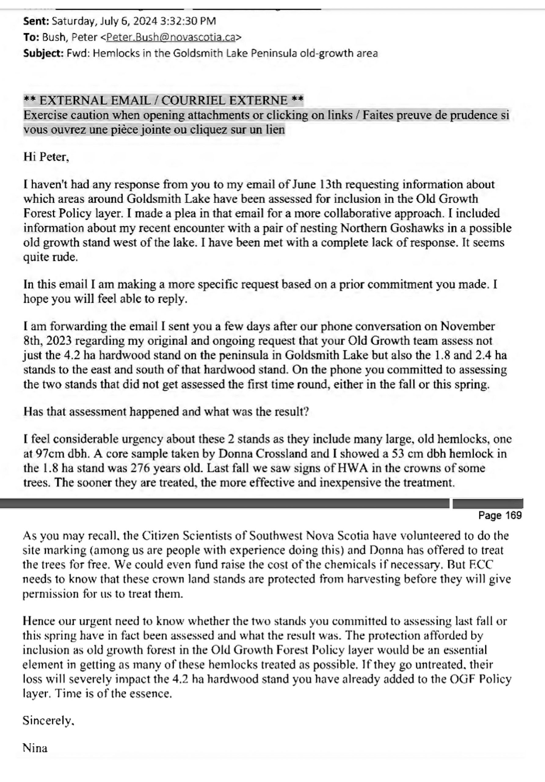
My letter to Peter Bush as revealed in FOIPOP
The Freedom of Information request I filed in November 2024, regarding DNR communications about old-growth forest around Goldsmith, yields this internal DNR correspondence regarding my July 6th email:

Internal DNR correspondence regarding my letter revealed by FOIPOP
A day later I got an email from Peter Bush, approved from higher up in DNR, that told me
nothing. The FOIPOP, meanwhile, shows that the two hemlock stands had in fact been assessed as Old-Growth by then.
This secrecy extended to the people employed to assess old-growth stands around Goldsmith Lake. Mersey Tobeatic Research Institute (MTRI) had been contracted by DNR to do the fieldwork. In the spring and summer of 2024 we would bump into their team in the woods and at the put-in at the lake. Needless to say we were curious about what they were finding, especially since we had found and reported a number of potential old-growth stands in the area. The FOIPOP reveals the team lead asking DNR what he was allowed to tell us. He was instructed not to give us any information about where they were looking or what they were finding. He was also reminded about the terms of the contract MTRI had signed with DNR.
On July 25th, the FOIPOP shows, Peter Bush wrote to the Executive Director of Forestry &
Wildlife at DNR, Matt Parker:

Further internal DNR correspondence regarding my letter revealed by FOIPOP
Peter Bush’s reference to the 2022 Old Growth Forest Policy for Nova Scotia in the email is
interesting. While he appears to be bending the knee more than the policy requires by
‘suggesting’ that the Executive Director can approve or disapprove additions of actual old-
growth forest (as opposed to ‘restoration opportunities’) to the Old-Growth Forest Policy Layer, Bush is also reminding the Executive Director that the Policy does not, at least by implication, give him that ‘responsibility’.
I may be reading too much into this email but it doesn’t sound to me as if Peter Bush is all that confident that the sites he has submitted will be added to the Policy layer shortly. As Old-Growth Forest Coordinator, he must have been aware that – other than the 4.2 ha hardwood stand on the peninsula – sites around Goldsmith Lake that had been assessed as old-growth in the 2023 field season still had not been added to the Policy Layer.
According to Section 8.0, the section of the Policy that Bush references in his email, it is the Executive Director’s responsibility to keep the Old-Growth Forest Policy map and data “up-to- date and available to the public.”

From the Old Growth Forest Policy
As the year slid by, and with it the opportunity for the hemlocks to get treated, I wrote again to the Ministers of Natural Resources and of Environment and Climate Change. ECC was more responsive than DNR. The November 2024 FOIPOP yielded this email between staff at ECC and the Old-Growth coordinator at DNR:

Further internal DNR correspondence regarding my letter revealed by FOIPOP
What was happening here, other than that I had, through polite persistence, earned my very own cone of silence?
Nothing, is the short answer. The window for treating the hemlocks in 2024 closed and still none of the old-growth areas identified at Goldsmith in 2023 or 2024 had been added to the Policy, except for the 4.2 ha hardwood stand the citizen scientists found on the peninsula.
7. ABOUT FOIPOPS
FOIPOPs – the acronym comes from the Freedom of Information and Protection of Privacy Act – are an essential tool, especially when faced with the sort of stone wall DNR throws up. They offer the only opportunity for citizen oversight of a bureaucracy that is in theory working on our behalf. Journalists rely on them. The Houston government’s attempt, as part of Bill 1, An Act Respecting Government Organization and Administration, tabled on February 18th 2025, to allow department heads rather than the Freedom of Information and Privacy Commissioner to decide that a FOIPOP application is ‘trivial, frivolous or vexatious’ was deeply alarming. Public pushback against this and against the attempt to put the Auditor General under the thumb of the government led to changes in Bill 1.* The decision as to which Freedom of Information requests can go ahead will remain with the Information and Privacy Commissioner
*See In the News – NS Democracy Issues (on this website) for news coverage of this and related issues.
That was a relief. I expect DNR senior management do find my FOIPOPs ‘vexatious.’ Without the documents they have yielded, we would have had no idea that DNR had identified so many stands of old-growth around Goldsmith Lake. We still don’t know why they are being so secretive. There are significant limits to how much information you can get through FOIPOPs. Civil servants are given periodic FOIPOP awareness training. For sensitive conversations, phone calls are preferred over emails since they can’t be FOIPOPed. Hence Peter Bush’s “Happy to discuss further on the phone” in his September 12th email
The reasons for DNR’s silence may also have been discussed in emails or portions of emails redacted under Section 14 (1) of the Freedom of Information and Protection of Privacy Act.
Section 14: advice by or for a public body or minister. 14(1), The head of a public body may refuse to disclose to an applicant information that would reveal advice, recommendations or draft regulations developed by or for a public body or a minister.
A portion of the first sentence of Peter Bush’s July 25th email was removed for this reason.
8. THE QUESTION REMAINS
In January, 2025 I was interviewed on CBC’s Information Morning about the puzzling
disconnect between what Freedom of Information requests show the government knows about Goldsmith Lake and what it has made public. View
Are magnificent stands of old-growth forest on Crown lands a State Secret in Nova Scotia?
Post on NSFM, Jan 10, 2025
By that point I had filed five FOIPOPs related to DNR and Goldsmith Lake. Three included old-growth in the search. The first of these, filed in February 2024, brought good solid information, including the core sample results for a 9.2 ha stand of hardwood forest on the west side of Goldsmith Lake. The Citizen Scientists and DNR had independently flagged this stand for assessment. The average age of the 5 core samples DNR took in that stand was 250 years. DNR’s age threshold for hardwood forest is 140. It was a spectacular find about which DNR remained silent.
The second old-growth FOIPOP, filed last July, yielded almost nothing. After consulting with the helpful administrator of the Access to Information program, I took another pass at the same period, adding some different search terms. This yielded the email Peter Bush sent to the Executive Director in July in which he reported all the 2024 old-growth forest finds. The email refers to an attached “PFD (sic) mapbook” but the mapbook was nowhere to be found in the FOIPOP documents
Eventually (after some darker conjectures) it dawned on me that the administrator’s computer software might simply be unable to open map attachments or shapefiles. With help from the administrator and Peter Bush, I finally was able to see a map with 7 new stands of old-growth. These did not include the 2 stands of hemlocks on the peninsula, nor the very old 9.2 ha stand. Perhaps those would be among 5 other old-growth stands I knew from the FOIPOPs had been submitted earlier. We were one step closer to knowing which stands had been assessed as old- growth but no closer to DNR making that information public.
It is not clear to me why such dogged persistence is required to extract information from DNR that they are in fact charged with making available to the public in a timely way. So I come back to the question, why all this secrecy about old growth forest on public land in Nova Scotia?
If DNR were working collaboratively with ECC and the public to meet the legislated target of protecting 20% of Nova Scotia by 2030, wouldn’t they want to share information that identifies some of the highest value conservation land in the province?
Such a question may seem laughably naive in the face of DNR’s history of prioritizing the needs and wants of the forestry industry over all others, but it shouldn’t be. We have a right to expect and demand better.
As Tim Houston said in 2019: “Any time a government tries to hide information and avoid scrutiny, the taxpayers need to be suspicious (…) secretive government is incompatible with good government.”
9. MOVEMENT AT LAST
In the new year, once my new PC MLA had an office, members of the Save Our Old Forests
board met with him. We mentioned how long it was taking DNR to make public all the old- growth stands around Goldsmith Lake. He said he would raise the matter with Minister Rushton.
Three and a half weeks later, on February 20th, I logged onto the Provincial Landscape Viewer and noticed a cloud of red around Goldsmith Lake.
The old-growth stands surrounding the lake had finally been added to the Old-Growth Forest Policy Layer. I was particularly happy to see that the stands of old-growth hemlock on the peninsula were part of the Layer. This spring they can be treated. With luck it’s not too late.

10. ONE LAST LOOK AT THE BOWATER MAP & A NEW MAP TO ENJOY
The screenshot from the Provincial Landscape Viewer, showing as it does only one other tiny fleck of old-growth in this whole stretch of Annapolis County from Annapolis Royal to Albany Cross, does rather make the case that Goldsmith Lake and the area surrounding it is special.
Is that why DNR senior management sat on the evidence of all that old-growth forest for so long? Because it undercut the picture they and WestFor painted of the area? The first time DNR sent the minister the Bowater map was in November 2022. They did it again in December 2023. In other words, DNR went on attaching the old Bowater map to briefing notes they sent the minister well after we identified the 4.2 ha stand of old growth on the peninsula, and well after they assessed the 250 year old 9.2 ha stand on the west side of the lake.
In Part I, I highlighted the fact that, while DNR drew their 2022 harvest plans onto the old map, they failed to draw in the 2 areas of long-recognized old-growth they had just expanded. Let’s look at how the old Bowater map looks now with all the newly recognized old-growth forests stands drawn in.

The New Map to Enjoy: Bowater map with Old-Growth Forest drawn in by hand by Nina Newington, March 2025
Most of the newly recognized old-growth coincides with areas Bowater shows as having been untouched. But not all. Clearly the peninsula is not the only place where an area that was supposedly cut or treated in the seventies turns out to have old-growth forest.
This reinforces the point I made earlier: neither DNR nor the Citizen Scientists should assume that areas the Bowater map indicates have been managed have in fact all been cut within the last 80 years and are of no conservation value.
In addition to the 14 stands of old-growth forest that have now been added to the Policy Layer, there are more stands awaiting assessment. And then there is all the old forest around the lake. Some didn’t quite meet DNR’s age threshold for old-growth; one stand, for example, came in at an average of 128 years old for the 5 samples. The threshold was 140.
But even if we only look at the 22 stands around Goldsmith Lake that DNR itself includes in the Old-Growth Forest Policy Layer, I fail to understand how DNR can refuse to recognize that the area should be protected. Old-growth is rare and precious. When you find this much of it ringing a pristine lake, headwaters of a known salmon river, isn’t the need to protect the whole area obvious? If not here, where?
Or will a future FOIPOP reveal that DNR is still attaching the old Bowater map to their briefing note for the minister as they prepare him for another protest and more media interest?
Here’s how Breck Stuart, the General Manager of WestFor, opened his Op-Ed in the Chronicle Herald in November 2022:
The area around Goldsmith Lake in Annapolis County has caught the eye of anti-forestry perspectives here in Nova Scotia. These 10,000 acres have been painted in the media as old, untouched pieces of forest that should be protected because of these qualities. We thought it would be important for the public to know this is just not true.
Will DNR ignore their own evidence so they can continue to peddle industry’s line?
Does it not matter anymore, what’s true and what isn’t? That way lies the madness going on south of the border.
Related (Update, Apr 14, 2025)
–  Lichen Camp 2025 Up and Running
Nina Newington on Friends of Goldsmith lake Wilderness Area FB Oage Apr 13, 2025, reproduced on NSFM “Happy to say Lichen Camp 2025 is up and running in the same spot as last year’s camp. We — a loose collection of people working to protect the proposed Goldsmith Lake Wilderness Area — are excited to continue with our research and education initiatives. It is our hope that this magnificent area will soon be identified as a candidate for protection to help the province meet its goal of protecting 15% of our lands and waters by the end of 2026.”
– What is getting in the way of protecting 20% of our lands and waters?
Post by Nina Newington on Healthy Forest Coalition website, Apr 10, 2025. “Shortly after coming to power in 2021, Tim Houston’s government tabled the Environmental Goals and Climate Change Reduction Act (EGCCRA). To their credit, it incorporated one of the election pledges the PCs ran on: to protect 20% of Nova Scotia’s lands and waters by 2030. In October 2023 the Canada-Nova Scotia Nature Agreement introduced an interim target of protecting 15% by 2026. It also gave Nova Scotia $28.5 million to help it get moving on meeting these protection goals…Back when EGCCRA was passed, at the end of 2021, 13% of our lands and waters had been protected. As of March 31st 2023, the grand total was 13.2%. At the end of March 2024, the total was 13.6%. At the end of 2024, the grand total so far protected stood at 13.7%. The next report is due in July. Tracked in the annual reports required by EGCCRA, reports titled Urgent Times, Urgent Action, this progress is, to put it mildly, underwhelming…”
Some of the discussion on social media
On Friends of Goldmsith Lake Wilderness Area – see post by NN on Apr 11, 2025
DGP: It might be described as Investigative Citizen Science; Nina and Co. have done us all a service by illustrating how we (Nova Scotians) are NOT being well served, in fact we are being served deceptively, by our DNR (Department of Natural Resources) in regard to management of our Crown Land Forests/Biodiversity Conservation/Climate Change-Carbon Storage and related commitments; also it illustrates the importance of protecting our Freedom of Access to Information (re: recent effort by Houston & Co, to restrict it). Added note: I believe it was never the objective of Nina & Co. to discredit DNR, rather they were seeking to engage DNR on their own terms, re: protecting old forests with critically obtained observations/facts which one would think would be welcomed, but evidently were not. It was only through frustration that they pursued FOIPOPs etc. and then told this story to help pressure change in DNR – to get them to do what they say they do and have promised to do, re Collaborative Prtected Areas Strategy etc.
NN to DGP: That’s true… We want to collaborate with both DNR and ECC to help achieve the goal this government put into law, the goal of protecting 20%. There was a period in 2023 when that sort of collaboration seemed much more possible. DNR reached out to Citizen Scientists and in July 2023 we met at Goldsmith to learn from their team how they assess old-growth forest stands. They were and are prompt and respectful in responding to the reports we submit to the Wildlife division every time we identify a new species at risk at Goldsmith (over 100 occurrences now.) But DNR’s willingness to communicate and work together seemed to disappear at the end of 2023.
GW: So partly what this indicates is that some types of harvesting don’t preclude forests moving into Old Growth?
This is an amazing writeup by the way. So much effort goes into these things
DGP to GW: I dont think that’s the case, Greg, rather they simply didn’t harvest those particular areas. NN suggests that in some cases it could be because they were not interested in hardwoods, and just didn’t see any reason to keep track of them otherwise – hence they’re not marked on the Bowater maps. Says NN: “I have a theory. It is no more than that. Bowater, as a pulp mill, was only interested in spruce and fir. When they had taken what they wanted and treated the areas they cared about, I think they marked the whole area as having been harvested and treated. Why bother to go to the effort of delineating a stand of hardwoods they had no use for? This would have been doubly true in an era before satellite imagery and digital mapping.” I found much the same in forests by Sandy Lake (Bedford) that were fairly intensively harvested (but not clearcut) the 1950’s/60s but in which patches of older forest (circa 130-140 years old in 2017) were not harvested. [In that case, there was evidence that a massive windstorm had levelled the whole area likely in 1869 (Saxby Gale) or 1873 (The Nova Scotia Storm) which limited the max age] I suggested that “these stands were simply missed or never got to in the days when these forests were harvested,” but perhaps in some cases they were simply not interested in hardwoods, or in hemlock as Nina suggests. See: https://versicolor.ca/sandylakebedford/forests/mature-og-forest. and https://versicolor.ca/sandylakebedford/forests for details.