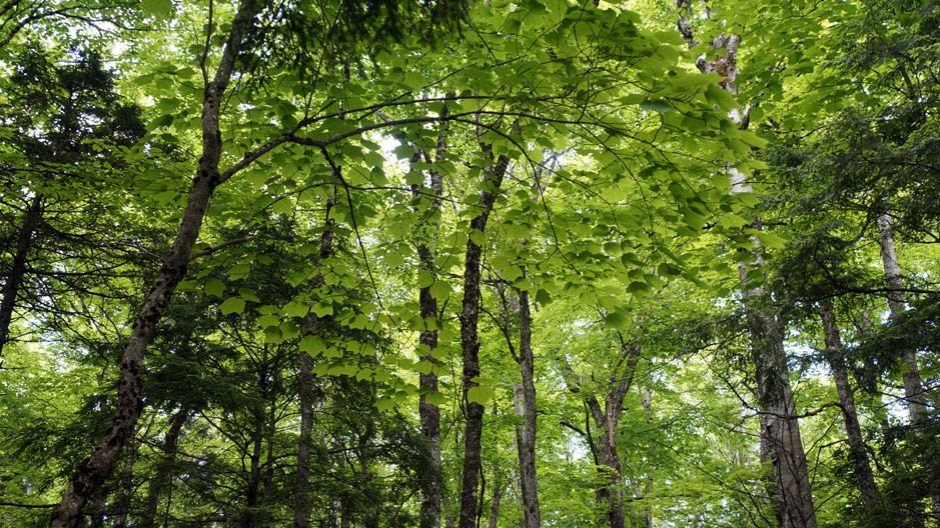

Old sugar maple stand approved for harvest in citizen-proposed Chain Lakes Wilderness Area.
By Nina Newington*
Shortly after coming to power in 2021, Tim Houston’s government tabled the Environmental Goals and Climate Change Reduction Act (EGCCRA). To their credit, it incorporated one of the election pledges the PCs ran on: to protect 20% of Nova Scotia’s lands and waters by 2030. In October 2023 the Canada-Nova Scotia Nature Agreement introduced an interim target of protecting 15% by 2026. It also gave Nova Scotia $28.5 million to help it get moving on meeting these protection goals.
*This post was first published as as a contribution from SOOF (Save Our Old Forests) on www.healthyforestcoalition.ca on Apr 10, 2025.
That same fall, the provincial government hired consultants to conduct an online survey on protecting 20%. 600 Nova Scotians responded. Just before Christmas, the government published the promised Collaborative Protected Areas Strategy. The section about the results of the survey concludes:
The desire for urgent action, a collaborative approach, and a transparent process were clearly articulated by participants.
 Back when EGCCRA was passed, at the end of 2021, 13% of our lands and waters had been protected.
As of March 31st 2023, the grand total was 13.2%. At the end of March 2024, the total was 13.6%. At the end of 2024, the grand total so far protected stood at 13.7%. The next report is due in July.
Tracked in the annual reports required by EGCCRA, reports titled Urgent Times, Urgent Action, this progress is, to put it mildly, underwhelming.
What has gone wrong?
As the Canadian Parks and Wilderness Society recently recognized, it’s great that Nova Scotia’s commitment to protect 20% by 2030 is in legislation. Good that the legislation requires yearly progress reports. Nice that the province published the Collaborative Protected Areas Strategy.
*On the Path to 2030: A Report Card on Progress to protect land and ocean across Canada by CPAWS, Mar 23, 2025.
But what’s next?
What is getting in the way of protecting 20% of our lands and waters?
 The Collaborative Protected Areas Strategy lays out criteria for selecting areas to protect. What it doesn’t do is establish the process by which this will happen. This is unfortunate because it is a big commitment:
- Following completion of existing protection commitments, approximately 300,000 hectares of additional protected and conserved areas are required to achieve the goal.
How are they going to protect this much land?
- Solution 1: We will identify, protect, and manage provincially administered lands and inland waters by identifying lands to support achieving 15 per cent by 2026 and 20 per cent by 2030. Each phase will include identification of a list of proposed sites, consultation, and designation of sites. From Collaboratuve Protected Areas Strategy, p. 11
So where is this list of proposed sites? The list that will take us to 15% by the end of next year is nowhere to be seen. The government’s formal process for assessing, consulting on and then designating sites for permanent protection takes time. Back in 2023, the Canada-Nova Scotia Nature Agreement stated that Nova Scotia needed to protect 82,500 ha to reach the 15% interim target. Having protected a quarter of one percent of our lands and waters since then, that figure is now 62,800 ha.
Where is that land going to come from? A tiny trickle of private land has been protected in the last three years as well as some sites that were already in process, but no significant areas of public (Crown) land have yet been identified. Why not? It is perfectly obvious that the province cannot buy enough private land to meet the protection targets. Acquiring private land for conservation takes tremendous dedication and resources. Land donations are lovely and often of great ecological value but they are rarely larger than 100 ha. The bulk of the land for protection must come from ‘provincially administered lands’.
According to DNR’s figures*, these total 1.854 million ha. With removals for roads etcetera, DNR gives a net provincially administered land base of 1,824,000 ha. Removing the 13.7% that has already been protected, the Crown land base from which new protected areas can be selected totals 1,070,500 ha.
*See High Production Forestry in Nova Scotia Phase 1 Final Report, NS Gov. July 2021
Meeting the 20% target is going to require protecting another 346,500 ha. The Department of Natural Resources (DNR) administers all Crown land; the Department of Environment and Climate Change (ECC), through its Protected Areas Branch, administers provincial Protected Areas. Once Crown land is protected, responsibility for it passes from DNR to ECC. The Collaborative Protected Areas Strategy requires those departments to work together. Both Ministers signed the ‘Message from the Ministers’ that introduces the Strategy.
It’s all about collaboration, this Strategy. Among the six guiding principles is:
- Connection and Collaboration – creating connections and collaborating with the public, Indigenous communities, and partners is essential to the development and implementation of this strategy and all associated protected and conserved areas
Collaboration – or the lack of it – between the departments and with the public is the major issue. It is what has stalled out a promising start.
DNR is known within government and to the public as a black box, exceptional in its refusal to communicate. This lack of transparency was identified in the 2009 Natural Resources Strategy, highlighted in the 2018 Lahey Report, and remains just as problematic in 2025. This does not augur well for a project requiring collaboration. And indeed Freedom of Information requests and the natural diffusion of information suggest that DNR has taken obstructionism to new heights when it comes to working collaboratively to achieve the 15% and 20% goals. Early on, rather than identifying possible sites for protection, DNR staff prioritized identifying areas of Crown land suitable for clearcutting and spraying (‘High Production Forestry’). Simply establishing regular meetings between ECC and DNR to work on protected areas proved challenging. The situation is even worse when it comes to transparency and collaboration with the public.
The Collaborative Protected Areas Strategy is specific about collaborating with the Mi’kmaq regarding identifying areas to be protected, engaging in meaningful consultation and creating a Mi’kmaq-Nova Scotia protected areas advisory group. I don’t know whether or not that advisory group has been established and is active. Certainly, it is good to see respect for Treaty Rights incorporated in the Strategy.
The Strategy also acknowledged the general public’s desire to participate in identifying areas that should be protected but it created no mechanism for us to do so. No advisory committee was established, nor any formal process by which the public could nominate areas for protection. Many Nova Scotians are passionate and knowledgeable about the public lands in their areas, with a deep familiarity developed by hiking, hunting, fishing, paddling, camping, foraging, bird-watching. The list goes on. For many in rural Nova Scotia this knowledge has come down through five or six generations. It is complementary to the information about areas of high conservation value that the Protected Areas Branch of the Department of Environment and Climate Change has assembled. It is also corrective to the famously inaccurate forest inventory data managed by DNR.
Besides the principle of the thing – a Collaborative Protected Areas Strategy should be exactly that – there is another very good reason to involve the public in meeting the goals of protecting 15% by 2026 and 20% by 2030: it is not going to happen without our help.
Progress, as I said before, has been underwhelming. Not only has DNR failed to work with ECC, it is working with the forestry industry to degrade the conservation value of areas that should be at the top of the list of sites identified for possible protection.
What am I talking about? The public, having clearly articulated our desire for urgent action, a collaborative approach, and a transparent process, has got on with the job of identifying multiple Crown land sites for protection. Groups in different parts of the province have submitted proposals for areas that meet the Collaborative Protected Areas Strategy’s criteria, documenting areas rich in biodiversity as well as rare or unique landscapes including species at risk habitat and old-growth forests.
How has DNR responded? By rushing through harvest plans to log in areas citizens have proposed for protection. Specific examples known to me where this is happening are the Chain Lakes Wilderness Area in Kings County; Goldsmith Lake Wilderness Area in Annapolis County; Ingram River Wilderness Area in Halifax County.
Far from working collaboratively with ECC and the public to protect the best of what is left of our forests, DNR is working hard to allow the forestry industry to cut what it can while it can. The effect is to fragment the few remaining areas with continuous mature forest cover. Our last intact primary forests are at stake.

AP022053, new harvest plan within proposed Goldsmith Lake Wilderness Area, put up for comment on HPMV November 2024, two years after citizen scientists proposed the area for protection. Red areas are recognized old-growth forest; stand with orange outline should be assessed as old-growth.
Although this government, in its second term, favours increased resource extraction, the Minister for Environment and Climate Change has reaffirmed the government’s commitment to meeting the 15% and 20% targets.
It is very poor governance indeed to allow one department – Natural Resources – to work at cross-purposes to another department when they have been mandated to achieve a common goal. It is also unwise to engage Nova Scotians in a collaboration they really care about – protecting our lands and waters – then trample on their efforts. Citizen scientists across the province are doing the work to identify sites to protect. It is past time for government to work with us to achieve what is supposed to be a common goal.